Blog Archives

Adventures in West Virginia
I recently completed the West Virginia Spartan Beast Last year, I had vowed to never do it again and there I was, dragging myself up the side of a mountain. I left home Friday morning so I could do some exploring. Of course, a lot of that time was spent just driving. I swear the prettiest places are so far away. Thankfully, I had one of my best friends with me so the trip didn’t seem too long.
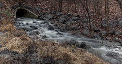
Our first stop was at Humback Bridge. Granted, this is in Virginia but close enough, right? It is so close to the highway it made sense to stop. The sky wasn’t great for photos. It was bland and gross. There wasn’t much water so the photos are so-so. We had the spot to ourselves, though, and that was cool. Again, it is too far away to go back very often but another trip during fall would be fun sometime.


Our second stop was the Glade Creek Grist Mill in Babcock State Park. I have seen so many photos of this place and, of course, wanted my own photos. As we neared the park, we received a heavy downpour. I was worried that we might be rained out, but thankfully it stopped just before we entered the park. Whew. I also hoped that it would provide some water for photos. We haven’t received much rain this summer (unlike last year) and I really wanted a nice waterfall photo.
We arrived and saw that there was little water. The only benefit to this was that we could skip around on the big boulders to get different compositions. We took our time and had photos in front of the waterfall – together and alone. My only wish was that I had changed my lens. I am having some issues with my normal lens. Things never quite look in focus and it showed in my photos. When a location is 5 hours away, you want the best photos possible. Granted, it is hard to take a bad photo of the place. It is incredibly picturesque. What I wouldn’t do to go back in the fall or winter (and maybe I will).


We could have maybe fit in one more stop after Babcock but I felt gross and just wanted to shower. Plus, the race was the next day and I wanted to rest up for it.
Yes, I finished the race. I shaved an hour off of last year’s time and that made me happy.
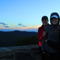
Sunday, on our way back home, we decided to do the Long Point Trail that gives you a good view of the New River Gorge Bridge. We made sure to read about the hike first because we had very tired legs from the race. Thankfully, the hike is very short with hardly any elevation gain. Perfect! The walk in the woods was nice. It felt good to stretch the legs. Walking after a race like that actually helps you recover more quickly as it gets the lactic acid out of the muscles (fitness tip!). We arrived at the overlook and only one other person was there. Bonus! We set up and took a million photos. We were there in the middle of the day so once again, my photos kind of suck. The light was very harsh but whattayagonnado? The view was amazing. It felt great to take some time and just sit there and appreciate it. Eventually, we decided to back. The drive would be long. As we hiked back to the car, at least 30 people passed us. We talked about how happy we were to not be there with all of those people. Many had dogs off of leashes and kids who were yelling. Not peaceful! (PUT YOUR DOGS ON A LEASH!!)


I always knew West Virginia was beautiful. I live so close to part of it but had never really visited that section. Last year, I did Sandstone Falls and Hinton, WV but this was way better. All I can think about is returning. Having a job and responsibilities really puts a damper on my traveling. I yearn for the days when I can just get in my camper and go!
West Virginia Spartan Beast Review
This past Saturday I completed my Spartan Trifecta. For those who may be new to me or to Spartan Races, let me explain. The Spartan Trifecta is made up of three races: The Sprint (3-5 miles), The Super (8-10 miles) and The Beast (12+ miles). To earn a “Trifecta” you complete all three races in one calendar year. I also did the Washington, D.C. (aka, Maryland) Sprint and the Asheville Super.
When I sign up for races I look at dates. Because I have two kids who play sports, my weekends are often taken up with their events. I try to cram my races into the summer and that gives me less options for racing. I also try to pick ones that are closest to me so that I can save money. When I go to Asheville, I stay with my brother. I can drive to and from Maryland. For West Virginia, I stayed at an AirBnB for the first time and it was perfect. After I signed up for West Virginia, I doubted myself. I knew it was going to be a hard race as it is classified as the North American Eastern Regional Championship. Spartan Race has a Global Championship and certain races are classified as “regional” or “national” championship. Winners gain entry into the Global Championship.
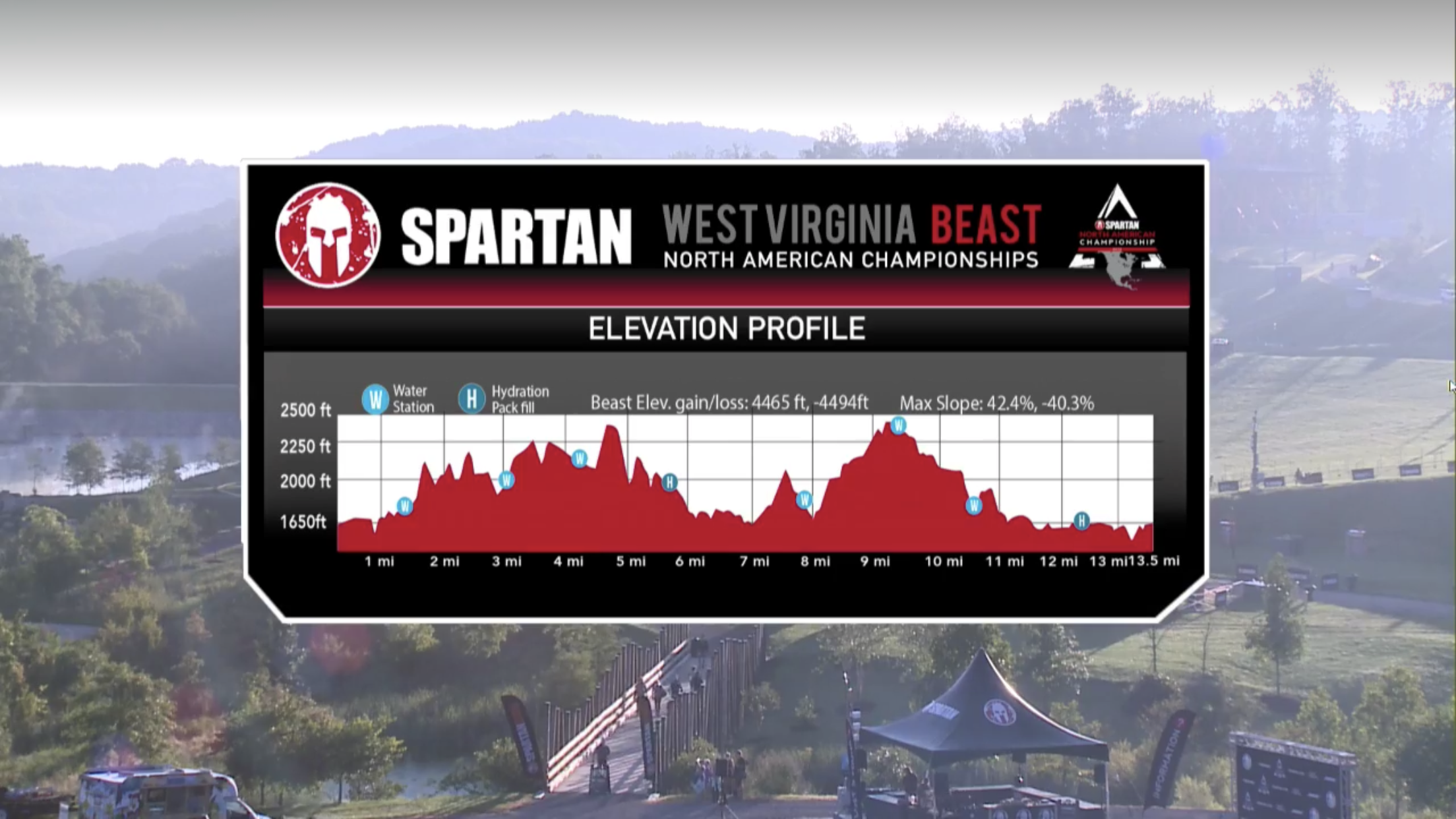
When I run these races I am not looking to win. That’s clear I think. What makes Spartan Races really cool to me is that we are running the exact same courses as the elite races. They cover the same mileage and obstacles (they just can’t have help like us open races) as we do – just much faster. This Beast took me 7.5 hours. Yes, that is a LONG time. I totally lost track of time. I knew, after I finished 3 miles, it had been only 1.25 hours. I had completed the first 3 fairly quickly and was pleased. I thought this meant I was going to finish in about 5 hrs. I was wrong. I was doing good running where I could – downhill and flat areas- there just weren’t that many. Much of this race included elevation: 4490 ft of elevation change over 13.5 miles. Some of that elevation was at a grade of 42%. You can reference this graphic to see how steep some of the elevation was. Fun fact: I bear crawled a bunch of it – way easier.
Race Details
I felt like I accomplished more obstacles than previous races. I’m able to scale most of the walls on my own and did receive just a small amount of help on a few others. I still cannot do the obstacles that require good grip strength – hanging, monkey bars, etc. This is a big frustration of mine and I really want to change this over the next year. But as a result of getting better at the other obstacles means I came away with very few bruises. I think I even avoided poison ivy at this race and that’s a big deal for me. I also have realized I can carry heavy things. The log, bucket, and sandbag carries were all pretty easy for me. I did set the bucket down twice but it was at the end and I was tired. I also had to swim during this race and I found that super fun.
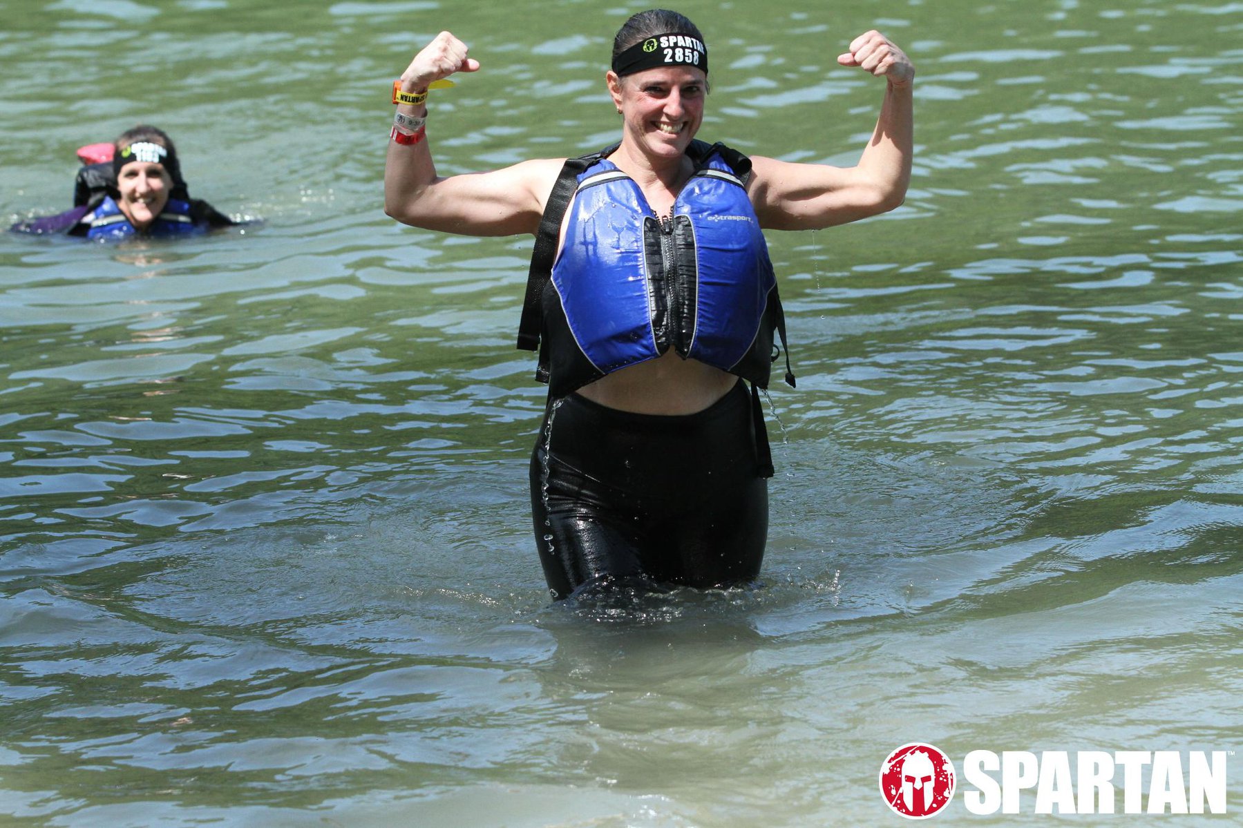
Swimming is Fun!
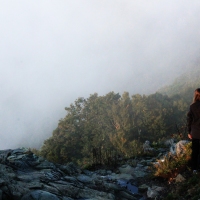
The place where the race was held: The Summit Reserve in Bechtel, West Virginia was beautiful. It is a Boy Scout Camp and one of the nicest “camps” I have ever seen. The views at the top of the mountains were wonderful. I loved seeing the peaks – it helped me feel accomplished. At one point, at the highest point, there was a dining room. It had glass windows all the way around and I could only imagine how amazing it would be to eat dinner in there during a beautiful sunset.
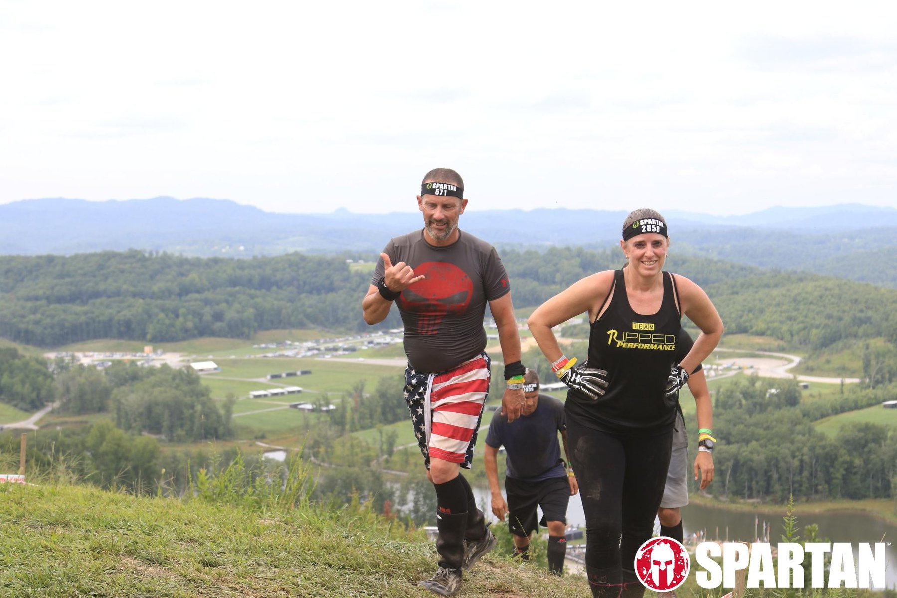
One of the Amazing Views
Overall, the race was about 15 miles (including obstacles). I am amazed at myself for finishing it. I wasn’t fully prepared for it. I hadn’t trained hard enough and felt it. I thought I had based on what people said about last year’s race, but, in good Spartan fashion, they made it harder. As I hiked, walked, and felt the pain, I told myself, “I never want to do this again.” But now, as I look back… I kind of want to…. I’m ridiculous.
If you haven’t ever done a Spartan Race and want a way to push yourself or have a goal I fully recommend trying a race. You can do the Sprint. I promise. Now that my Trifecta is done… I will relax a bit, probably gain a few more pounds, and then start in on my training. I am going to visit a couple of OCR gyms in the area and train on the grip obstacles. And maybe, in 2019, I’ll complete the Sprint and do it all without burpees!!
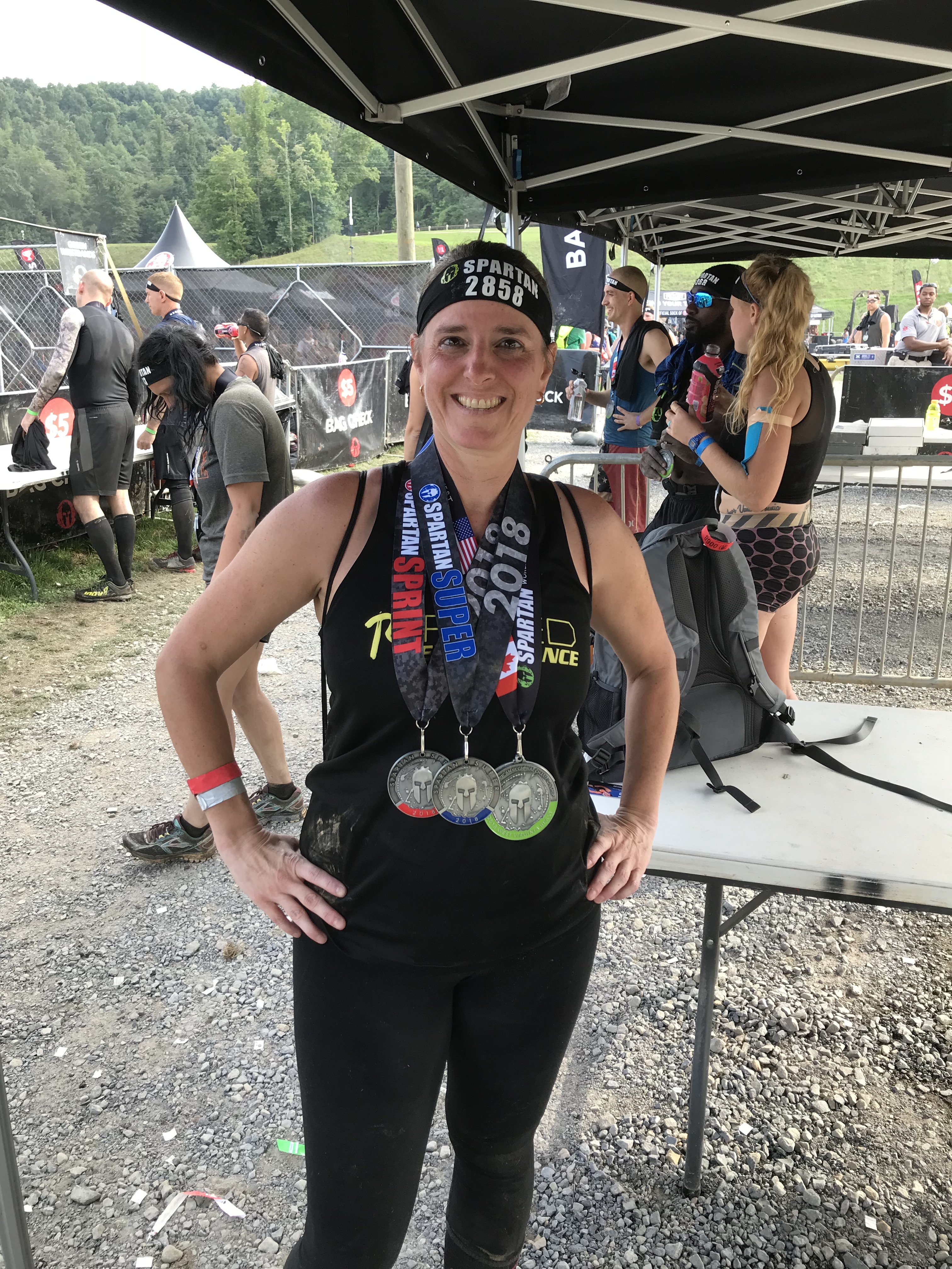
Trifecta Medals

Visiting Bush Creek and White Oak Falls in West Virginia
Our original plans for spring break were to stay in our cool cabin for two nights and then head to Claytor Lake State Park for two nights. I was excited to try a new Virginia State Park – especially for the sunset possibilities. As we were coming off of the mountains at Grayson I received a phone call. I didn’t know the number so I figured they would leave me a message if it was important. When I reached the bottom of the trail I checked the message with the little bit of signal I had left: Claytor Lake had canceled our reservations because the whole park lost power. It would not be restored for days. Heartbreak. I think they lost power due to the snow storm.
So I figured we’d just drive into town, find WiFi, and I’d figure something out. I wasn’t sure what… well, “town” was much farther than I anticipated so I drove back to Grayson where I knew I had some signal. I called VA State Parks and we settled on Hungry Mother State Park – a place we stayed at two years ago. My son was thrilled because he knew that meant a fire in the fireplace… aka… s’mores. And it was close. But what would we do? My hikes were planned for around Claytor. I researched the awesome Outbound and found some waterfalls. I reached out to an Instagram buddy and he confirmed a location and gave me more tips about it. Perfect.
That location was Bush Creek Falls in West Virginia. The drive was approximately 1.5 hrs from Hungry Mother. I chose to drive on the back roads instead of hitting I-81. Anyone from Virginia knows you avoid I-81 at all costs! The rural country was beautiful. I stopped to take a few photos (will do a write-up on them later) along the way and on the way back. Eventually, we reached the falls.

//embedr.flickr.com/assets/client-code.js
Due to the melting snow the water was incredibly high. The falls sounded loud and powerful. It was a sight to see. The hike to Bush Creek is only half a mile at the most. I got very excited to shoot the waterfall until I picked up my camera and realized my nub was missing. I’m sure the “nub” has a more official name but basically it is the connector that fits into my tripod. It’s rather important for waterfall photography. I instantly got upset. I thought, “All the driving, time, and now I can’t take photos.” I turned and saw that my son was upset. He said, “So we’re only here for photos?” Thanks, babe. I needed that because I realized, photos or not, I was there for him.

//embedr.flickr.com/assets/client-code.js

//embedr.flickr.com/assets/client-code.js
Thankfully, with my smaller 18-55 mm lens, my camera actually balances perfectly. I could set it on the tripod and it would say there. Of course, I couldn’t get too many good angles it forced me to be creative. In the end, I’m glad for it. The shots I got while resting the camera on a rock/log actually are some of my favorites – perhaps of any waterfall shots I’ve ever shot. There weren’t a lot of places to stand next to the creek since the water was so high so we didn’t spend a lot of time there. My Instagram pal had said to continue down the trail. So we did and it was an adventure.
There were little, mini waterfalls flowing down the side of the mountain (?) to our right and then down to the creek. We had to be creative with our crossings until, eventually, one was too deep and we had to just walk through it. As I stood trying to figure out how to take photos of these mini waterfalls my son declared, “That’s it. We can’t go any further.” There were a group of trees down across the trail. I surveyed it and knew we could get through it. One of my goals for the trip was to show my son that just because something requires effort doesn’t mean it isn’t worth doing (like homework). This was perfect. I found a way through for us and tried to explain this to him. Maybe he’ll remember it in the future.

//embedr.flickr.com/assets/client-code.js
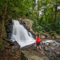
Finally, we got to White Oak Falls. They were magnificent. It was a tiered waterfall with huge boulders. I again had to be creative with my shots. I tried a few things. And while I would have preferred having my wide angle lens on my camera, I think I ended up with a couple of photos that show how cool the falls were. I had to stand right in the water for quite a while to get them. Worth it.

//embedr.flickr.com/assets/client-code.js

//embedr.flickr.com/assets/client-code.js
We meandered back to the car. My feet were soaked and I was anxious to get back and shower. I felt good about the day. I hope it is an adventure my son remembers since we had to walk through water, cross trees, and explore a waterfall. If you’d like to have specific information on how to find both sets of falls, please refer to my post on The Outbound. If you haven’t yet joined The Outbound, please use my invitation link.
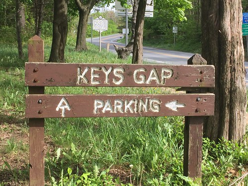
Hiking Keys Gap – Appalachian Trail
 //embedr.flickr.com/assets/client-code.js
I was happy to have some time on Mother’s Day to go for a quick-ish hike / trail run. I had remembered that I wanted to check out the portion of the Appalachian Trail that is pretty close to my house so I abandoned my kids and took off for the trail. Keys Gap is about a 25 minute drive from my house – depending on how many slow people are driving on Rt 9. I was worried the trail might be busy with people out hiking with their moms but the parking lot was almost empty.
I took off running on the trail but quickly encountered pretty deep mud. I am not scared of running or hiking through mud but I still took my time to go around the deepest parts. When I could, I would run but soon I was slowed by the number of rocks on the trail. I wasn’t interested in falling or twisting an ankle so I took my time and just hiked.
 //embedr.flickr.com/assets/client-code.js
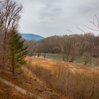
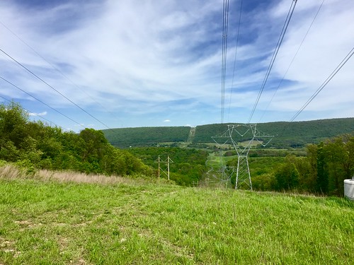
This trail leads to Harper’s Ferry. Since I got a late start there was no way I was going to make it all the way there. I also thought that there might be more views on this trail but in the distance I went (2.5 or so miles one way) there was only one look-out area thanks to some big power lines. On my way back I passed a family who was out for a hike and the mom asked me if there were views. I was sad to tell her there was just that one. It’s a decent one but made ugly by the power lines.
 //embedr.flickr.com/assets/client-code.js
The week’s worth of rain we received really made everything very green. I’m very much a scenery hiker. I like to look at things and see views and pretty nature. This trail isn’t the greatest for that. I did pass a large rock wall (no indication if it was original, new, or private property). And the rocks along the trail were kind of cool but I missed seeing “things”. If I had gone south I think I would have had more views so I will definitely consider that next time. I’m also anxious to hike out to Harper’s Ferry and back at some point.
I had the trail to myself for 90% of the time. On my way back I passed that family hiking and I encountered a woman hiking with 6 dogs. They were all very cute and friendly but I can’t imagine that task of getting them clean once arriving home. I played music without headphones for the first half of the hike. I turned it off for the second half so I could just enjoy the solitude. Also – why do squirrels sound like the largest animals in the forest. Can’t they run with a little more delicacy?
I can’t wait to go back and experience more of the Appalachian Trail when I have more time. I definitely will be taking it south to Buzzard Rocks and then going all the way to Harper’s Ferry.
Check out all my photos from the hike.
 //embedr.flickr.com/assets/client-code.js