Blog Archives
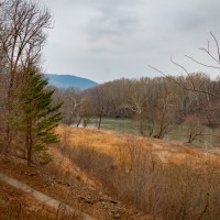
The Most Beautiful Place in Virginia
Can you guess it?
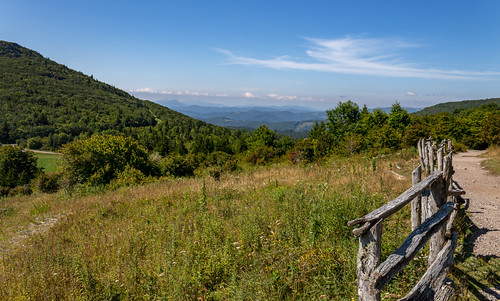
I have been through a lot of Virginia. All of it? No, of course not. There are some famous places I haven’t been yet. But I have been to Shenandoah National Park (numerous times, obviously, if you read this blog) and to parts of Southern Virginia. When my son and I went to Grayson Highlands State Park back in March of 2018, I was blown away. I knew I would need to return, multiple times, to experience the area.

The day after we hiked The Channels, we drove over to Grayson. My daughter was a big jealous we had gotten to see the ponies who live in the park. Keep in mind that she was feeling jealous while visiting The Galapagos in Ecuador… (insert laugh here) I told her we’d go and check another box before she leaves for college. When we first arrived to the park, we headed straight for the visitors center so my girl could get a shirt. I told my daughter that I expected to hear, “Wow!” at least once, unprompted. That’s how beautiful the area is and if she didn’t notice it, I’d be mad. And then we had to go to the camp store to get some pain medication for my son. Finally, we arrive at Massie Gap to start looking for ponies. We climbed up the Rhododendron Trail and on to the horse trail. We saw a white spot out in the distance and got excited. The climb seemed so easy. When my son and I hiked the area it was thick with snow and seemed to take us forever.
 //embedr.flickr.com/assets/client-code.js
We got closer and closer to the white spot and then…. it was a steer. Cows also roam the highlands and we got fooled from far away. Thankfully, as we looked over to the Appalachian Trail we saw more! Off we went! We were treated to a group of about 5-6 ponies who were happily munching on the grass and vegetation. We stood for awhile watching them. It is always a thrill to me to encounter animals on a trail and ponies are no exception.
 //embedr.flickr.com/assets/client-code.js
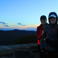
Finally, we decided to hike back. We still had to drive 5.5 hours back home on a Sunday on the dreaded I-81. I didn’t want to leave. I wanted to climb higher elevation and see the mountains go on forever. I wanted to hike on to Mt. Rogers and finally stand at the highest elevation in Virginia. Basically, I didn’t want to leave. I see a lot of mountains from blogs that I read. I have visited the Rocky Mountains. The Tetons. The Great Smokey Mountains. I have been in Arizona and Yosemite. All beautiful. The Blue Ridge Mountains, though, give me a feeling I can’t quite describe.
 //embedr.flickr.com/assets/client-code.js
Just two weeks left before I take her to college…. *tears*

Visiting Virginia’s Newest State Park

Last Friday, as I have for the past few years, I decided to #optOutside rather than hit the stores that morning. I had wanted to visit the newest state park in Virginia: Widewater State Park. The morning was chilly but there was little to no wind so it wasn’t bad wandering around the park.
The park is small. And it is a little difficult to find. I would suggest reading directions on the Virginia State Park’s site or using Google Maps. The other map services didn’t have quite the right location. Once you arrive you end up next to the Potomac River and Aquia Creek. If you like water, this is a great park. There is a location to launch a boat and, when it is warmer, it will have paddling available. When we entered the park I noticed there were no envelopes available. Also, I did not see any park rangers working so there was no way to pay the fee. Hopefully, they will have envelopes in the future because I always want to pay my way at State Parks.
Once we parked, I noticed there was also no large map on a sign anywhere. It made it difficult to know where the trails were. Thankfully, we had seen one on our way in and walked to that. It is a short trail at only 1 mile. It is currently the only trail available in the park. It winds by Aquia Creek, into a small wooded area, next to a pond, and back to the parking lot. We also went off trail a bit just to get some more steps into our day.
Looking back at the map online, I see that we could have driven to an alternate location on the Potomac River. I would have liked to do that as we did see two eagles fly overhead. Maybe we could have seen more over on the river.
Overall, the park has great potential. It was completely quiet. My friend and I were the only two at the park. When it warms up, however, I think the park will be busy. Hopefully they will add more trails to the park because the land is beautiful. When you get a chance, I definitely suggest heading out to check out the park.

Outside with my Son
If you have read my site regularly you’ll know that I have had issues getting my son to get outside with me. He always loved to go hiking and exploring with me and then this past spring he announced that he didn’t like it at all and only went with me to make me happy. While it is sweet he wanted to make me happy – it also stung.
Last weekend we had a free afternoon. His soccer game got canceled so I announced to him that he was going with me outside and that was it. He couldn’t say no. He said, “Okay.” and gave no other argument. I feel like that is a small win. I didn’t have big hiking plans. I honestly wanted to get outside, take some photos, and wander around. Some of our most fun times have been when we just wander from spot to spot.

Mooooooo
We ended up at Sky Meadows State Park in Delaplane, VA. We’ve been here a few times and I promised him he could go fishing at the pond. We first stopped and visited the cows. I like cows and think they are funny creatures. I wasn’t too successful and getting them to moo as I usually am but it was fun taking their photos. We headed down a nearby path and honestly, we turned around. It was boring even to me (I had thought it was a different trail). This is what happens when you’re so confident and decline a map.

Walking the trail
We decided to drive to a different portion of the park. If you leave the main area and go back to the road, you turn left and there is an old farm across the road with more trails. It is called the Lost Mountain area. We parked there and headed down a path. I guess if I really wanted a nice, pleasant walk I would return to this trail. It was flooded from all the rain and muddy. That really wasn’t an issue but it made it difficult to walk and, again, not much to see. So we turned back, again. I will make a note, though, to return and hike to the top of Lost Mountain.

The old barn
I took photos of the barn and we headed across so my son could go fishing at Turner Pond. As we drove up, a man was taking photos of a large bass he had just caught. That gave us hope that he would also catch something similar. So we fished. And fished. And moved around. The older man kept catching fish and we caught nothing. But it was a lot of fun trying.

Fishing at Turner Pond
Again, we wandered down a trail that is marked as the start of a 5K. I was more interested in the barns behind the trail and wanted to see if I could get a good photo of them.

The larger barns were nice but I preferred this
As I headed back, my son was on one of the ParCourse things (sections along a trail that allow for exercises). He was trying to balance on a pole and I finally saw glimpses of the boy who really loved the outdoors. He yelled at me, “Quick! Take my picture!” He reminded me of a photo I took years ago at Scott’s Run Nature Preserve where he wanted to “meditate in nature”. I was more than happy to take his photo. We ended up exploring and wandering for about 1.5 hrs and that satisfied me. I love spending time with him outside and seeing how excited he gets. I don’t think he realizes how much he likes it. He commented that the sun was too hot and he didn’t enjoy that. And so perhaps as it cools down he’ll be more open to going with me.

Inside he is telling himself not to smile and let me know how much fun he’s having. haha
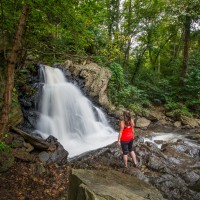
If you haven’t visited Sky Meadows State Park in Virginia, definitely put it on your list. The views are beautiful. They have wonderful trails and you can hike on the Appalachian Trail.

Visit to Grayson Highlands, Part 2
If you’d like to read about Part 1 to Grayson Highlands, please click here.
Our original plans for Grayson Highlands (other than seeing all the ponies) was to hike to Mt. Rogers. Mt. Rogers is the highest point of elevation in Virginia. I kept thinking how cool that would be. I have been to Pike’s Peak in Colorado and thought adding another highest peak would be a nice note on my hiking successes.
Monday morning we woke up and waited a bit. It had turned pretty cold and everything had frozen. I wanted it to warm up before we started. We arrived at the park (after I stopped again for various photos) and we talked about what to do. There was a waterfall that we could hike to or we could try for Mt. Rogers. I let my son decide and he chose Mt. Rogers. Off we hiked.

//embedr.flickr.com/assets/client-code.js

//embedr.flickr.com/assets/client-code.js
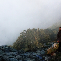
Because it had gotten so cold, all the trees had rime ice. It was magical. In one area, the wooded area appeared to be a frosted fairyland. The cold also made it much easier to hike. In many areas, my son just walked on top of the snow. I sank down so I followed footsteps already created. I felt like we were going at a good pace, but, eventually my son started to get tired. Although he’s an avid soccer player, hiking legs are something different. He was having fun but going slow. The snow didn’t help. I would stop and take photos (I couldn’t stop). We ran into some ponies and that took time. We rested and had lunch. We arrived at one point and it said, “Mt. Rogers: 2 miles”. 2 more miles? That meant we had gone approximately 2.8 miles in 4+ hrs. Go ahead, you can laugh.

//embedr.flickr.com/assets/client-code.js

//embedr.flickr.com/assets/client-code.js

//embedr.flickr.com/assets/client-code.js
I honestly felt disappointed. I knew that 2 more miles in the snow would be difficult for my son. Did I really want him to be upset? Sad? That wouldn’t make for good memories. My disappointment wasn’t as important. We turned around and headed back. We got passed by two trail runners in shorts and winter coats. At that point, I laughed. My son was decked out in a full snowsuit complete with trekking poles and snowboarding goggles. I was dressed very heavily as well. And there they were… two guys just running down the Appalachian Trail towards Mt. Rogers. I checked our elevation and we had reached almost 5,600 ft. I’d say that’s pretty close considering Mt. Rogers is 5700 and change.
In the end, it was good that we turned around when we did. It started to warm up. The sun and weather felt really good but that meant slush. The snow became difficult. I grabbed one pole from my son because I was sliding all over the place. To be honest, I don’t have winter, or well, any season of hiking boots. I have a couple pairs of trail shoes that I use. I was wearing my winter boots. I had nothing else. By the time we reached the car, the knee I sprained last year was feeling really bad. I can’t imagine if I would have had to hike 4 miles in the slush.

//embedr.flickr.com/assets/client-code.js

//embedr.flickr.com/assets/client-code.js

//embedr.flickr.com/assets/client-code.js

//embedr.flickr.com/assets/client-code.js
By the time we finished, we were both tired. It had been a quick trip back but the snow was tiring. I know that I’ll go back another time, with no snow, nice weather, and get to Mt. Rogers. It is just over 8 miles round trip and the hike itself was not difficult. Heck maybe I’ll even run some of it. The views could not be topped. I have included quite a few photos here but if you’d like to see all of them, click on the link below. Any photos that you like can be purchased. I haven’t added any to my website yet but will soon.
If you haven’t been to Grayson Highlands yet, please put it on your list. I think it is quite possibly the most beautiful area of Virginia.

//embedr.flickr.com/assets/client-code.js